We are an industry leading company that specialises in GPS & Rate controllers for all types of farming operations.
• Record multiple fields and jobs, including applied products (fertilizer, herbicide, fungicide etc).
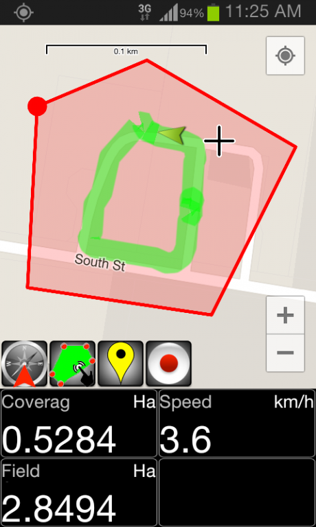
• Record and calculate field and job/coverage area based upon field boundary, distance travelled and implement width, with recording start and stop.
• GPS area calculation works for both field boundary area, and job coverage area or manual selection.
• Import and export field boundaries, and export job coverage trails, in KML format.
• Record field features as marked points with descriptions.
• Moving map display allows North-Up or Heads-Up operation.
• Works with metric and imperial units.
We welcome any suggestions via our support email for future additions.
Manual can be downloaded from Here
If you are looking for Windows Tablet Based Software visit www.farmscan.ag
Please note that 3G & GPS is required for operation. If 3G is lost maps will fail to load. We are working on this for future releases.
We do not host Farm Mapping GPS Utility on our servers. We did not scan it for viruses, adware, spyware or other type of malware. This app is hosted by Google and passed their terms and conditions to be listed there. We recommend caution when installing it.
The Google Play link for Farm Mapping GPS Utility is provided to you by apps112.com without any warranties, representations or guarantees of any kind, so access it at your own risk.
If you have questions regarding this particular app contact the publisher directly. For questions about the functionalities of apps112.com contact us.

|
| ||||
| Downloads: 29 | ||||
| Updated At: 2024-04-23 11:01:15 | ||||
| Publisher: Farmscan AG Pty Ltd | ||||
| Operating System: Android | ||||
| License Type: Free Trial |